

The storm strengthened into a hurricane on Wednesday on a likely path toward Florida
By NBC6 Staff • Published 5 hours ago • Updated 2 mins ago
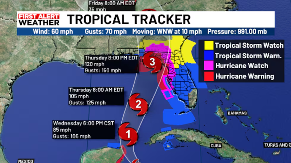
Key Information:
- Tropical storm warnings were issued for Monroe, Miami-Dade, Broward, and Palm Beach counties on Wednesday due to Tropical Storm Helene.
- Helene initially developed on Tuesday in the northwestern Caribbean Sea and intensified into a hurricane by Wednesday.
- The storm prompted hurricane watches as well as tropical storm warnings across parts of Florida.
- Forecasters expect Helene to gain strength as it moves through the Gulf, with the potential to become a major hurricane before making landfall.
- Landfall is predicted to occur along Florida’s Gulf coast, possibly as early as late Thursday.
Helene intensified into a hurricane on Wednesday as it tracked through the Gulf of Mexico, heading toward Florida.
Earlier in the day, a tropical storm warning was issued for all of South Florida, including Miami-Dade, Broward, Monroe, and Palm Beach counties.
Helene has the potential to strengthen into a major Category 3 hurricane by Thursday before making landfall along Florida’s Gulf coast.
Forecasters are closely monitoring Helene’s progress, as it gathers strength over the warm Gulf waters. Residents along the Gulf coast are being urged to prepare for the storm’s impact, which could bring dangerous storm surges, heavy rainfall, and damaging winds.
Emergency officials are advising those in vulnerable areas to review evacuation plans and stay updated on the latest advisories. Coastal communities may face significant flooding, while inland regions could experience widespread power outages and wind damage.
Authorities are also warning of potential disruptions to travel, with airports, highways, and local transit systems expected to be affected as Helene approaches. Preparations are underway to minimize the storm’s impact, but residents should remain vigilant and heed any evacuation orders issued by local authorities.
Helene’s Path Toward Florida
Current Storm Track and Predictions
As Helene continues to move northwest across the Gulf of Mexico, meteorologists anticipate that it will make landfall around Florida’s Gulf coast. Although the storm’s precise route is still unknown, communities from the Panhandle to the Tampa Bay region may be most at risk, according to current projections. Residents around the state are being urged to stay prepared for a possible change in the storm’s direction by the National Hurricane Center, which is providing frequent updates.
Potential Impact Zones
Although Helene’s course is uncertain, Gulf Coast coastal areas in Florida should brace for major effects. Within the anticipated cone of uncertainty are cities like Pensacola, Tampa, and Fort Myers. Severe weather, such as torrential rain, powerful gusts, and perhaps tornadoes, might potentially hit inland locations. As the storm approaches, residents in areas vulnerable to flooding are warned to remain on high alert.
Preparedness Measures for South Florida
Evacuation and Shelter Plans
Monroe, Miami-Dade, Broward, and Palm Beach counties are among the local authorities in South Florida that are closely monitoring the situation and may issue orders for evacuation if things get worse. There are evacuation routes being developed, and locals are urged to become acquainted with the shelters in their area. People who live in coastal or low-lying locations should be prepared to relocate to higher ground if needed.
Emergency Supply Checklist
Before Helene arrives, locals should make sure they have all the supplies they’ll need. This comprises flashlights, batteries, first-aid kits, and enough food, drink, and prescriptions to last for at least three days. To ensure connectivity during possible power outages, fill up cars with gas, save critical documents, and fully charge mobile devices. It’s also critical to monitor local news and weather reports.
Potential Risks and Hazards
Storm Surge and Flooding
Potentially fatal storm surges are one of the biggest threats brought on by Hurricane Helene, particularly along the Gulf Coast region. When storm surges cause water levels in low-lying areas to rise quickly, it can result in severe coastal flooding. High tides and a lot of rain could exacerbate floods, especially in areas that are already vulnerable. To avoid harmful conditions, residents are recommended to heed all municipal cautions and evacuation advisories.
Wind Damage and Power Outages
With increasing intensity, Helene’s strong winds may cause extensive damage. Particularly susceptible areas include roofs, trees, and electrical lines, which could result in protracted power disruptions. In order to get ready, homeowners should secure outdoor furniture, prune trees, and reinforce windows and doors. Utility staff are also getting ready to respond to outages; however, recovery periods may differ based on the intensity of the storm.
Florida’s Response to Hurricane Helene
State and Local Emergency Actions
The state of Florida and the local government in the impacted areas have started to assemble emergency response teams. In several coastal districts, the governor has already declared a state of emergency, enabling quicker access to federal resources and triggering the National Guard to support relief and evacuation operations. In anticipation of Helene’s possible impact, emergency operations centers are working in tandem with first responders, weather forecasters, and public health organizations.
Public Transportation and Infrastructure Preparations
As Hurricane Helene approaches, public transportation in susceptible areas may be halted or scaled back, and airport operations may see disruptions or delays. To facilitate traffic flow for those fleeing dangerous locations, main evacuation routes have had their highway tolls waived. Bridges, flood control systems, and electricity grids are examples of public infrastructure that is being guarded and observed, with additional staff on call to handle any possible damage. Additionally, ports may close, and marine traffic is being diverted onto safer paths.
Weather Outlook After Helene’s Landfall
Potential for Severe Weather Inland
Even after Helene makes landfall, its effects could be felt far inland. Heavy rain and flooding are expected to extend well beyond the immediate coastal regions. Areas in central and northern Florida could see several inches of rain, which may cause flash floods and dangerous road conditions. The storm’s outer bands could also bring isolated tornadoes, increasing the risk of damage in areas not directly hit by the storm’s core.
Post-Landfall Conditions in Neighboring States
As Helene moves further inland, neighboring states such as Georgia and Alabama may experience severe weather, including heavy rainfall, gusty winds, and the possibility of flash flooding. Local authorities in those states are closely monitoring the storm’s progress and may issue warnings as Helene continues its path. Residents in these areas should stay updated and prepare for potential impacts.
Recovery Efforts and Post-Storm Safety
Immediate Steps After the Storm
Following the storm, the emergency response teams in Florida will concentrate on determining the extent of damage and initiating the process of recovery. Following Helene’s landfall, locals should stay away from the impacted areas as fallen power lines, water, and debris could pose safety risks. While power companies will make every effort to restore electricity as soon as they can, full service restoration in the most affected areas may take days or even weeks.
Health and Safety Precautions Post-Storm
Public health experts are advising locals to take preventative measures in the wake of Hurricane Helene in order to avoid accidents and illnesses. Driving through flooded areas or wading through standing floodwater might be dangerous for your health. Furthermore, food safety should come first in the case that power outages persist for a long time, and generator use should be done carefully to avoid carbon monoxide poisoning.
FAQs
1. How dangerous could Hurricane Helene be for Florida?
Helene could become a major Category 3 hurricane before landfall, bringing life-threatening storm surges, heavy rainfall, and strong winds, particularly along the Gulf coast. The storm’s exact impact will depend on its final path and intensity.
2. What areas are most at risk from Helene?
Coastal areas along Florida’s Gulf coast are at the highest risk, especially from storm surges and flooding. However, inland regions could also experience severe weather, including heavy rain, tornadoes, and power outages.
3. Should I evacuate if I live in South Florida?
If you live in a flood-prone or low-lying area, or if local authorities issue evacuation orders, it’s essential to follow their guidance. Preparations should be made early, and residents are encouraged to evacuate to higher ground or local shelters if necessary.
4. How long could power outages last after the storm?
The duration of power outages depends on the severity of the storm’s damage. While utility companies are preparing crews to restore service as quickly as possible, outages could last from several days to weeks in heavily impacted areas.
5. What precautions should be taken to stay safe during and after the storm?
During the storm, remain indoors, away from windows, and avoid flooded areas. Afterward, avoid downed power lines and debris, and use generators safely. Stay tuned to local authorities for updates on recovery efforts and potential hazards.
6. When is Helene expected to make landfall?
Helene is projected to make landfall along Florida’s Gulf coast, possibly late on Thursday, but the timing may shift based on the storm’s speed and trajectory.


